8
Days
8
Max Group Size
Medium
Difficulty
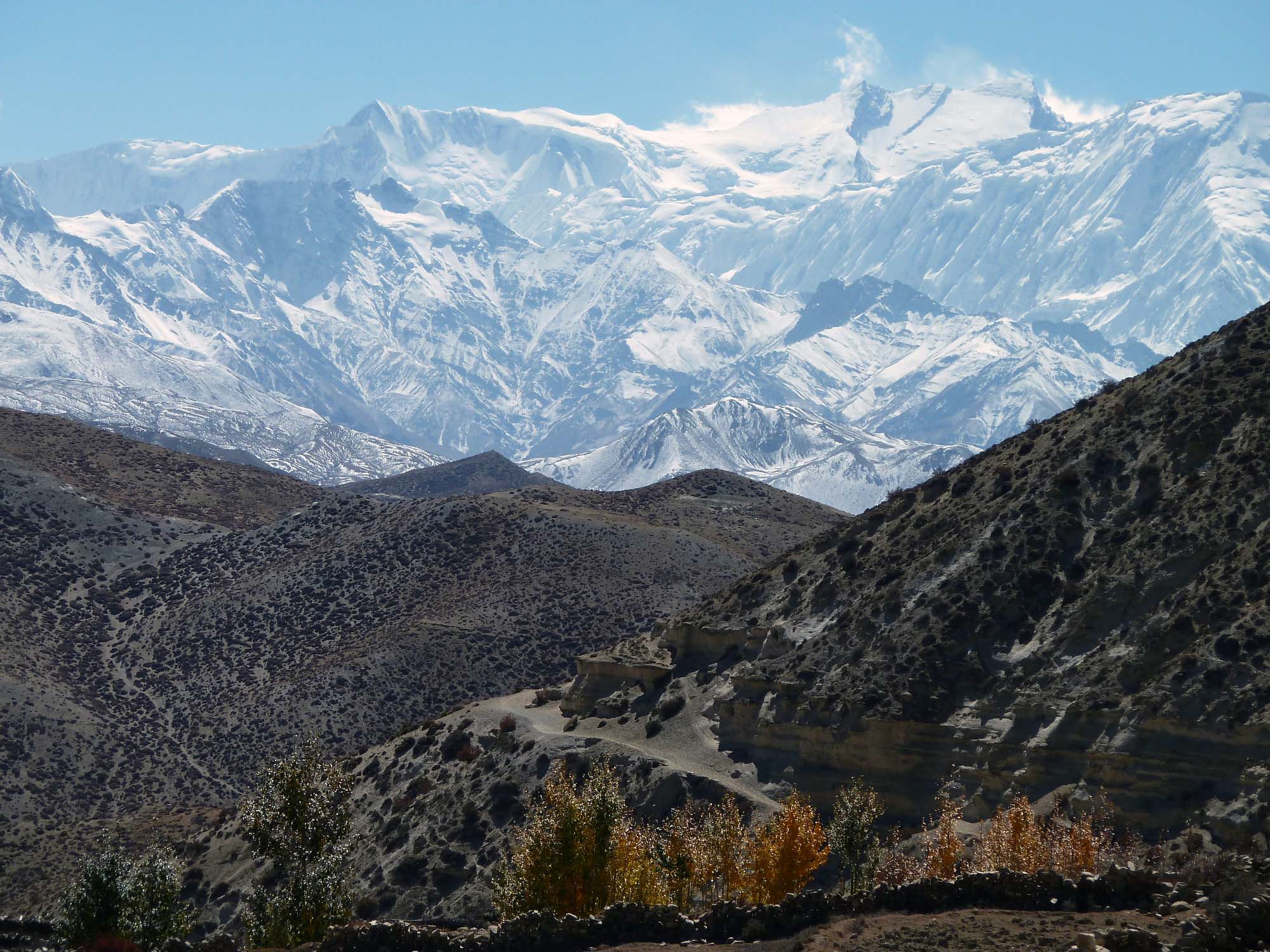
Trekking Expedition
Mustang District
Gandaki, Nepal
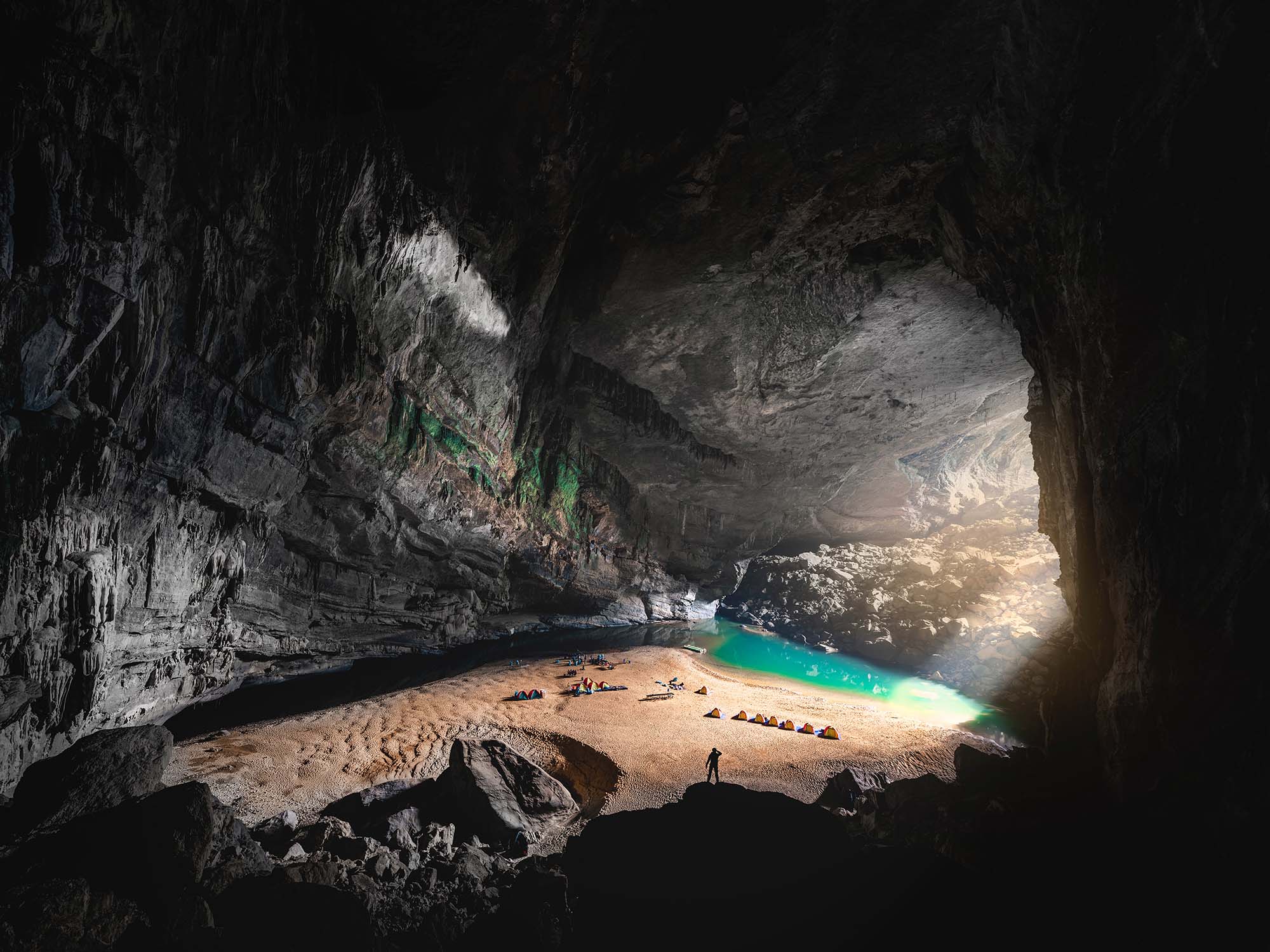
Go deep — in one of the largest caves on Earth
Quảng Bình Province, Vietnam
Hang Én is the third largest cave in the world, after Hang Sơn Đoòng in the same national park, and Deer Cave in Malaysia. The cave has its own jungle, waters, beach, and climate. There are three known entrances to Hang Én.

The destination and the expedition
Phong Nha-Kẻ Bàng (Vietnamese: Vườn quốc gia Phong Nha-Kẻ Bàng) is a national park and UNESCO World Heritage Site in the Bố Trạch and Minh Hóa districts of central Quảng Bình Province in the North Central Coast region of Vietnam, about 500 km south of Hanoi. The park borders the Hin Namno National Park in Khammouane Province, Laos to the west and 42 km east of the South China Sea from its borderline point. Phong Nha-Kẻ Bàng National Park is in a limestone zone of 2,000 km2 in Vietnamese territory and borders another limestone zone of 2,000 km2 of Hin Namno in Laotian territory. The core zone of this national park covers 857.54 km2 and a buffer zone of 1,954 km2.
The park was created to protect one of the world’s two largest karst regions with 300 caves and grottoes and also protects the ecosystem of limestone forest of the Annamite Range region in North Central Coast of Vietnam.
Champa inscriptions carved on steles and altars in the cave demonstrate that people had inhabited the cave long before the area was annexed by Vietnam in the Nam tiến or southward expansion. In 1550, Dương Văn An was the first Vietnamese man to write about Phong Nha cave. This cave was depicted in 9 urns in the Citadel of the Nguyễn Dynasty in Huế. In 1824, The cave was conferred the title “Diệu ứng chi thần” (妙應之神) by King Minh Mạng. It was also conferred by Nguyen kings as “Thần Hiển Linh” (神顯靈).
In the late 19th century, Léopold Michel Cadière, a French Roman Catholic priest, conducted an expedition to explore Phong Nha cave, where he discovered Champa scripts. He proclaimed Phong Nha cave “The number one cave of Indochina”. In July 1924, an English expeditionist (surnamed Barton) stated that Phong Nha cave is second to none of famous caves of Padirac (France), Cuevas del Drach (Spain). In 1935, a local inhabitant accidentally discovered a beautiful cave 1 km from the mouth of Phong Nha cave, at an elevation of 200 meters. It was called Tien Son cave (lit.: Fairy-tale cave), or Dry cave because its inside landscape is similar to fairy-tales and it has no underground river.
Phong Nha–Kẻ Bàng National Park is in the territories of communes (Vietnamese: xã): Tan Trach, Thuong Trach, Phuc Trach, Xuan Trach and Son Trach of Bố Trạch District and a small part of Minh Hóa District in the center of Quảng Bình Province, around 40 km north-west of the provincial capital city of Đồng Hới. The park is bordered by the Hin Namno karst area of Khammouane Province of Laos in the west. Road distances are about 500 km south of the capital Hanoi and 260 km north of the port city of Đà Nẵng. The geographical coordinates are 17°32′14″N 106°9′5″E.
The park is around 30 km west of the South China Sea and National Route 1A, near Hồ Chí Minh Highway and 28 km west of the Hanoi–Saigon Railway, and is accessible by road or waterway through an estuary in the South China Sea. There is a small airport near the park accessible by helicopter or small aircraft (Khe Gat Airbase), an airbase used by the North Vietnamese Air Force during the Vietnam War, notably in the Battle of Đồng Hới.
Before becoming a national park, this area had been a nature reserve. The Phong Nha Nature Reserve with an area of 50 km2 was officially declared by the Vietnamese government on 9 August 1986 and was extended to 411.32 km2 by 1991. On 12 December 2001, the Vietnamese Prime Minister by Decision 189/2001 189/2001/QĐ-TTG turning then a nature reserve into a national park. The purpose of this protected area is to protect forest resources, biodiversity within the boundary of this national park and to preserve scientific values of fauna and flora in Bắc Trung Bộ region, especially rare species native to this region. The park covers a total area of 857.54 km2 which are divided into three zones, a “strictly protected zone” (648.94 km2), an “ecological recovery zone” (174.49 km2), and an “administrative service zone” (34.11 km2).
Like North Central Coast in general, and Quảng Bình Province in particular, the climate in Phong Nha–Kẻ Bàng national park is tropically hot and humid. The annual mean temperature is 23–25 °C (73–77 °F), with a maximum of 41 °C (106 °F) in the summer and a minimum of 6 °C (43 °F) in the winter. The hottest months in this region fall from June to August, with an average temperature of 28 °C (82 °F), and the coldest months from December to February with an average temperature of 18 °C (64 °F). Annual rainfall is about 2,000 mm to 2,500 mm (80–100 in). 88% of the rainfall falls during the monsoon, from July to December, however, there is more than 160 rainy days per year, and some rain still falls throughout the dry season. Mean annual relative humidity is 84%.
for the coming year
 from $1649
 from $1999
 from $1919
 from $949